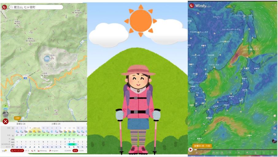
Check the weather, wind, temperature and rain in advance using the free weather forecast app “WINDY” and enjoy safe and enjoyable mountain climbing.
- Windy.com Mountain weather check
- summary:
Windy.com Mountain weather check
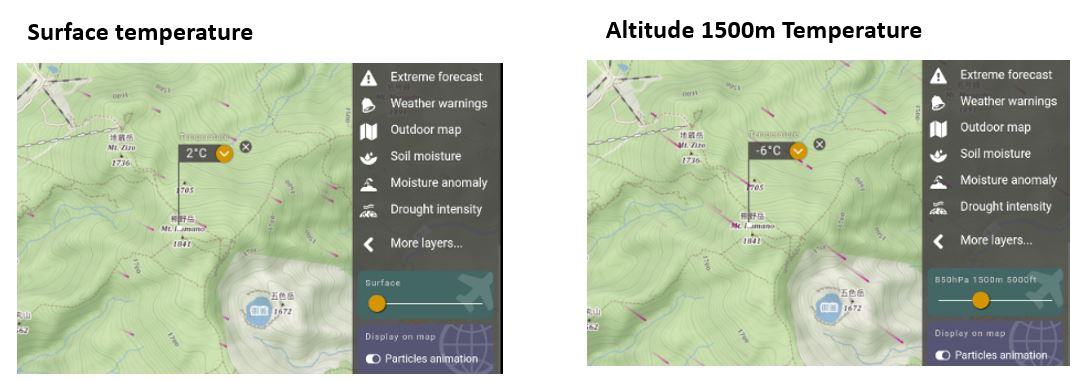
Note that when you check the mountain weather on Windy.com, the weather forecast for the ground at zero altitude is displayed in the initial state.
When you want to know the wind and temperature, humidity at the summit, adjust the altitude slider and display the weather picker to display the wind and temperature, humidity at that altitude.
Conversely, other layers cannot be confirmed for each altitude.
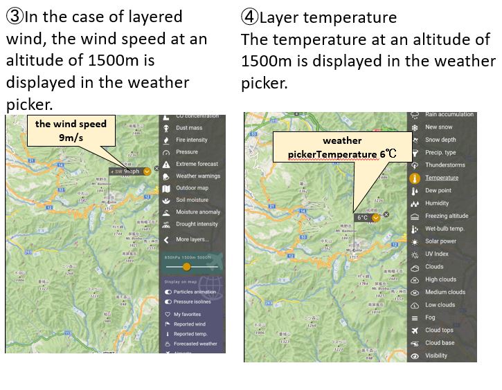
You can check the altitude slider every 950hPa (about 600m), 975hPa (about 750m), 900hPa (about 900m), 850m (about 1500m), 800hPa (about 2000m), and 700hPa (about 3000m).
To explain it concretely, enter the mountain you want to go to in the place search window, for example “Mt. Fuji”
Then the weather forecast for the ground (altitude zero) is displayed. (Weather at the foot of the mountain)
When you want to know the wind and temperature at the summit, adjust the altitude slider and display the weather picker to display the wind and temperature at that altitude.
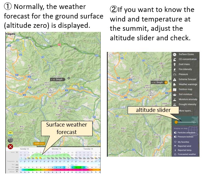
Altitude setting
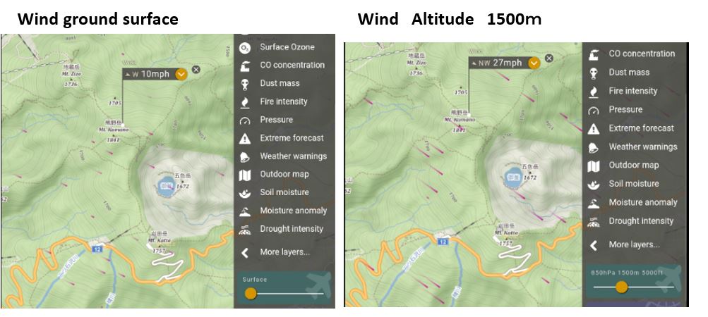
By default, the wind speed on the ground is displayed, so when climbing, you can adjust the altitude slider under the layer menu to the altitude of the mountaintop to display the wind speed in the sky such as 900m, 1500m, 2000m, 3000m, 5500m. Is possible.
Temperature defaults to surface weather information, typically the temperature drops by 0.6°C every 100 meters.
If you adjust the altitude slider in Windy to match the altitude of the mountaintop, the temperature will be displayed at that altitude.
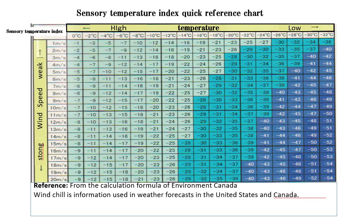
Climbing sensible temperature wind chill
The temperature you feel in your daily life, the so-called sensible temperature, may differ greatly from what the meteorological observatory reports, and wind speed is a major factor that affects the sensible temperature.
Simply put, it feels like the temperature drops by 1 degree per 1 meter of wind speed.
Even if the temperature is 0°C, the sensible temperature is minus 10°C under a wind of 10 meters.
Choosing what to wear in the mountains is a matter of life and death.
Many of the mountain distress accidents were due to lack of preparation, as they were unable to move due to hypothermia because they did not have warm clothes.
In the mountains, you should think about the worst possible situation, and clothing selection is fundamental.
The table below is a sensible temperature index calculated from the temperature and wind speed used in the North American continent and serves as a guideline for knowing the degree of risk of frostbite outdoors.
In the case of exposed bare skin, if the sensible temperature index falls below -28°C, frostbite may occur within 10 to 30 minutes.
When checking the temperature at the top of the mountain with Windy, consider the sensible temperature index calculated from the wind speed, prepare clothes, and try to climb safely and enjoyably.
Climbing Rain forecast and measures
Climbing on rainy days has the potential to lead to accidents and serious injuries.
Hypothermia can occur, for example, when the skin and clothes get wet with rainwater.
When climbing, be sure to pack your rainwear in your backpack.Also, swamps and rivers are swollen, visibility is bad, and it is dangerous.
The mountain trail is dimly lit with the sunlight blocked, and sometimes you may get lost because you don’t know where you are walking.
Before climbing, check weather information such as Windy to see if there is an approaching cyclone, tropical cyclone, typhoon, or cold front.
It is also possible to check the occurrence of clouds in the mountains using the “Meteogram” function of Windy, which is helpful.
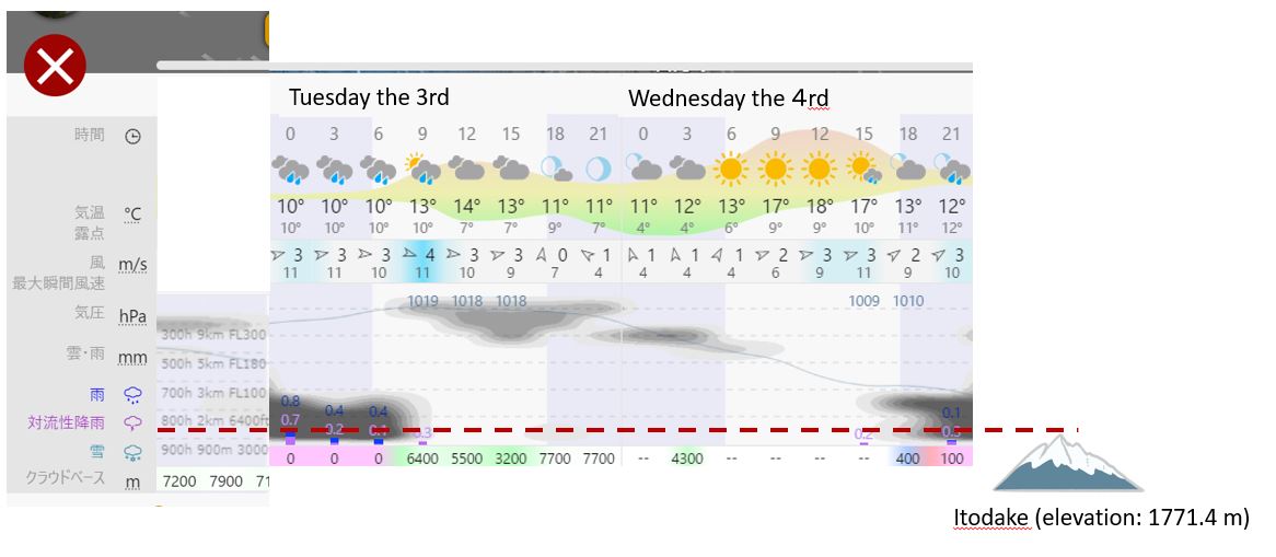
Windy Meteogram
You can see the clouds at different altitudes.
When “Meteogram” is selected, temperature, dew point temperature, wind, and cloud cover/rainfall/convective rainfall by altitude (9km, 5km, 3km, 2km, 900m) are displayed in chronological list.
Therefore, you can see “weather” and “degree of cloudiness” at a glance.
*At ground level it is 1013hPa (1 atmosphere), and as the altitude increases by 1000m, the atmospheric pressure decreases by about 100hPa.At the summit of Mt. McKinley (6190m), the atmospheric pressure is about 394hPa.
*Flight Level (FL) is one of the flight altitudes used in aviation.”FL” followed by a number in units of 100 feet.
Windy Meteog Cloud Forecast
For example, if you climb Itodake (elevation: 1771.4 m), the morning of Tuesday the 3rd, the summit will be covered by clouds at an altitude of 800 h 2 km, so visibility will be poor due to fog, and sunrise will not be possible.
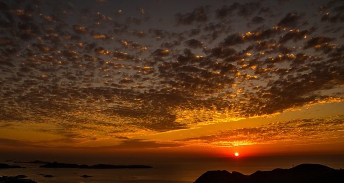
However, in the evening, the lower level clouds will dissipate and only the upper level 300h 9km clouds will be visible, so the sunset is expected to be visible on the horizon.
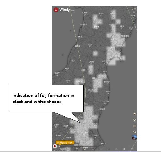
Mountain climbing Fog, gas forecast and measures
There are places where fog is likely to occur due to topographical surfaces and natural conditions.
As the temperature rises, the air near the ground cools and the morning fog disappears.
Fog is a state in which water droplets and moist particles that are smaller than raindrops are floating, so when you are in the fog for a long time, wear rain gear to keep your clothes dry.
Also, be careful as the stones and rocks on the mountain trail are wet and slippery.
“When you are covered in fog, it is necessary to remember how to use the GPS and compass and how to read topographical maps in order to avoid getting lost.”
In Windy, there is a fog item in the layer, and you can see the occurrence of fog with black and white densities,
but please note that the weather conditions at the top of the mountain are different because it is information on the ground surface (altitude zero).
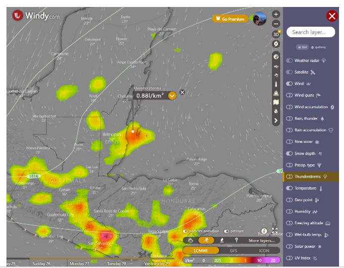
Climbing Thunder forecast and measures
Before climbing, check weather information such as Windy to see if low pressure, tropical cyclones, typhoons and cold fronts are approaching.
In Windy, you can check the forecast in the layer “Thunderstorm”.
Defined as the number of flashes of light in an area of 1 square kilometer in a day, the unit used to express the intensity of a “thunderstorm‘’ is “l/km2‘’.
l is the average total lightning density. The name of ECMWF is Averaged total lightning flash density in the last 3 hours
Abbreviation is litota3
The ECMWF description shows the total lightning flash rate averaged over the last 3 hours.Having units of flashes per square kilometer per day, it is easier to understand by converting to units of flashes per 100 km2 per hour.
引用先:ECMWF
The higher the number, the higher the probability of lightning occurrence.
(the more the color becomes red or purple)
Please also check the lightning radar of other weather apps before climbing.
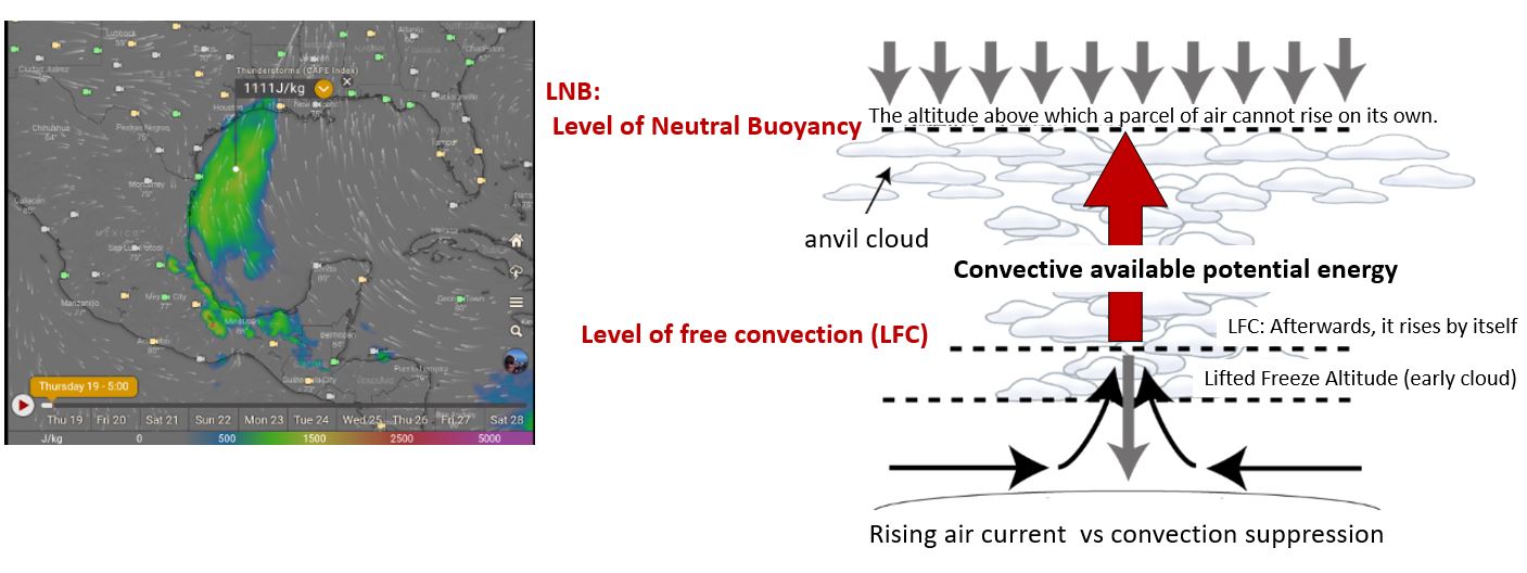
The layer CAPE index (convective effective potential energy)
The layer CAPE index (convective effective potential energy) is also useful for lightning forecasts. Stable up to 1000.
Values from 1000 to 2000 can indicate forming of moderate thunderstorms, and over 2000 severe ones.
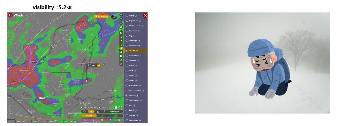
Climbing whiteout forecast and measures
One thing to watch out for when climbing mountains in winter is the whiteout, which can make visibility extremely poor due to snowstorms. There are many victims every year by deviating from the route.
In whiteout, the boundary between the snow surface and the sky is lost, creating the illusion of floating in a white space. You will not be able to move, and the blowing snowstorm will drain your health.
If you step on a snow cornice by mistake, you may slide down, and eventually you will not be able to move, and you may end up doing nothing.
The basic countermeasure is to secure a place that can withstand the blizzard or create a snow cave and wait until the weather calms down.
Please check the visibility situation in advance with Windy’s layer visibility (visibility) before climbing.
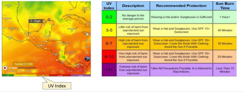
Climbing UV protection
In the case of high mountains, the air layer through which ultraviolet rays pass is shorter than on the ground, so the ultraviolet rays are stronger than on the ground.
An increase in altitude of 1000m increases UV radiation by about 10%.Also, during the remaining snow season, you need to be careful of the reflection of the snow on the ground.
UV rays are invisible. In mountains with low temperatures, you may be exposed to strong UV rays without realizing it.Even if the sky is cloudy, 60 to 80% of the UV rays on a sunny day are pouring down.
You can check the UV forecast in the weather information before climbing, and you can check it with the layer UV index (ultraviolet index) in Windy.
The UV index (ultraviolet index) is an index designated by the World Health Organization to clearly indicate the degree of influence of ultraviolet rays on the human body.
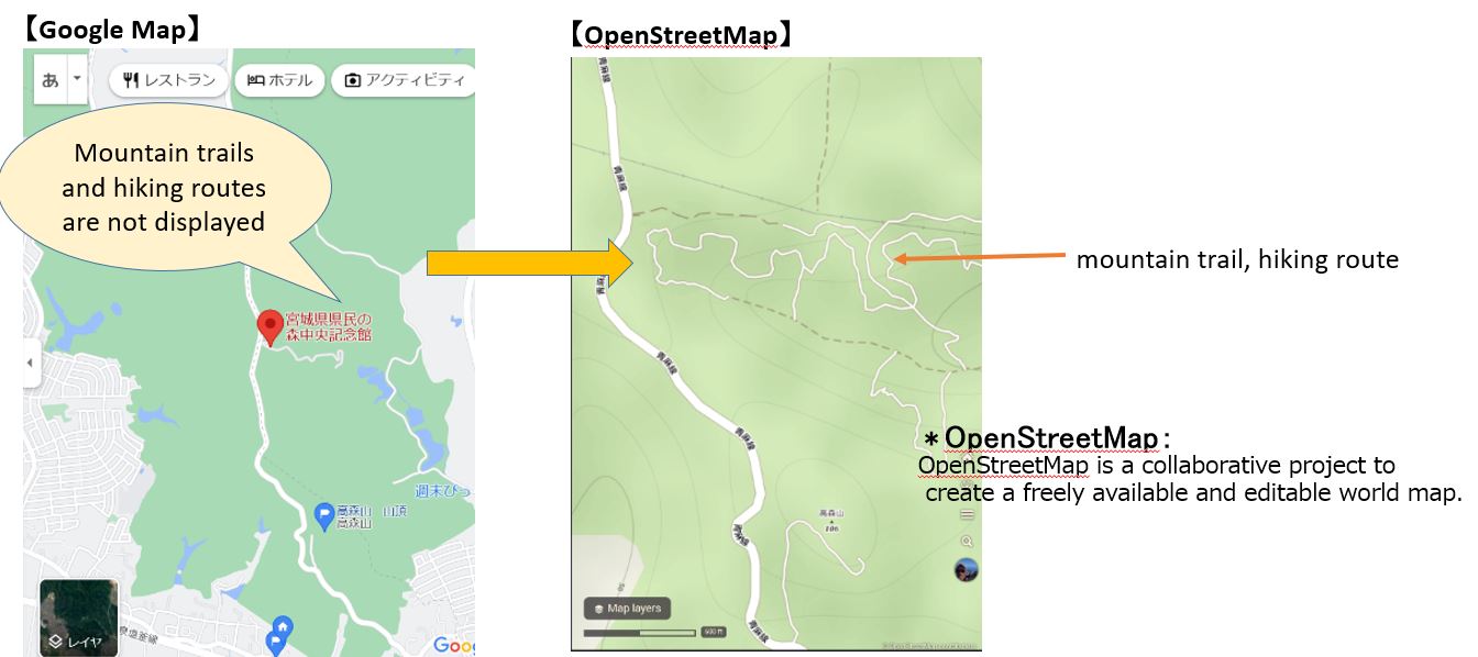
Layer Outdoor map
It can be used as a hiking map using Open Street Map.
Open Street Map also displays mountain trails and hiking routes in an easy-to-understand manner.
summary:
The weather forecast app Windy.com is a free app that tells you the weather conditions at a glance on a screen that visualizes weather information around the world.
However, it is prohibited to be overconfident with Windy.com alone.
Please also check the weather forecast of others App.
Windy Related article
Windy’s related article is below, please refer to it.
How to use Windy.com for sea, river, mountain weather forecast
windy.com Types and descriptions of the display on the map
Windy.com Mountain Climbing Utilization Editionきうん)Windy.com What kind of layer?
Windy.com Utilization of fishing
Windy.com Surfing Utilization Edition
Windy.com Diving Utilization Edition
Windy.com Skiing, snowboarding Utilization
コメント