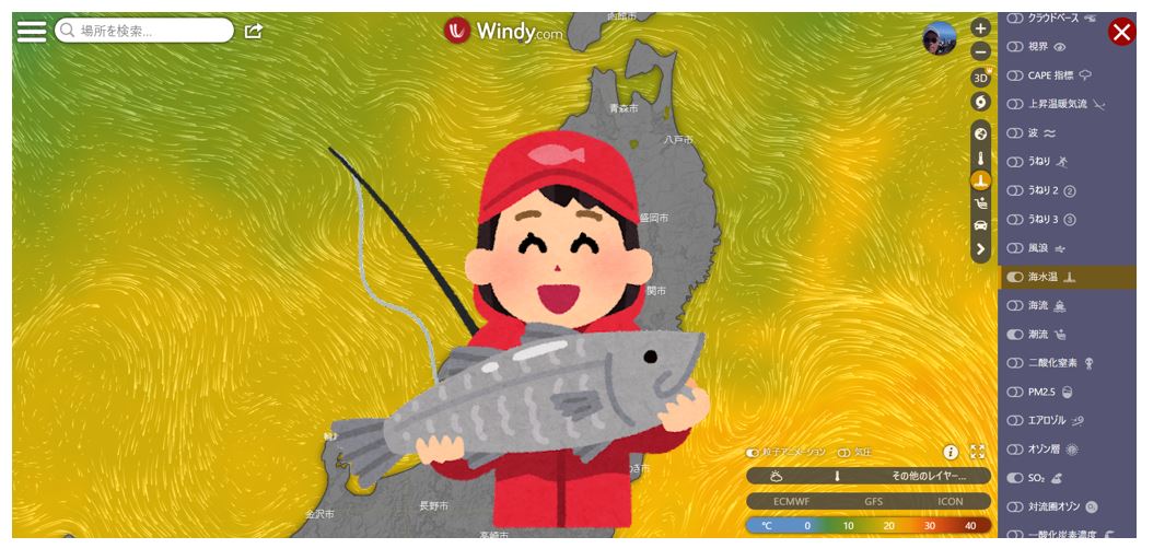
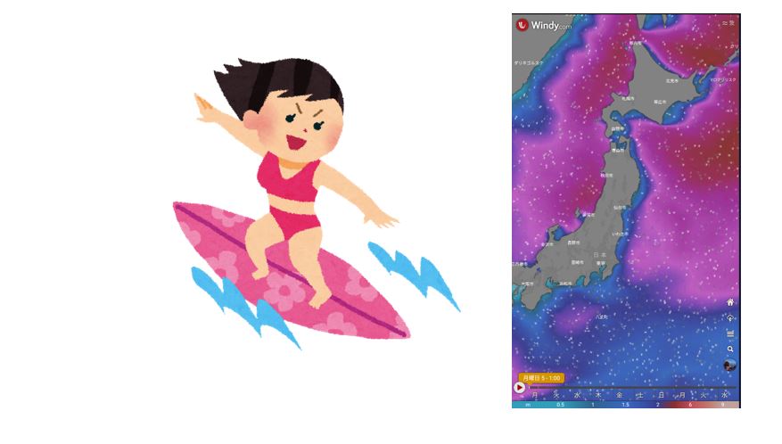
- Windy.com Utilization of fishing
- Seawater temperature and fish activity
- Check seawater temperature
- Fishing-Find back wind!
- Fishing Search for waves and swells!
- Fishing – Onshore, Offshore
- Check wind force, wind direction, wave height, wave period, wave direction
- Tide forecast tide graph
- Fishing – tidal currents, ocean currents
- Fishing Rain forecast and measures
- Fishing Fog, gas forecast and measures
- Fishing Thunder forecast and measures
- summary:
Windy.com Utilization of fishing
Absolutely recommended for fishing! Free weather forecast app “WINDY” Wind speed, waves, seawater temperature, temperature, weather, ocean currents, tidal currents
Seawater temperature and fish activity
If the seawater temperature becomes too low, the activity of fish will generally decrease. If the activity drops, even if you drop the bait in front of the fish, it will not bite, so the fishing results will be difficult. The minimum seawater temperature is 15°C or more, and the optimum seawater temperature is about 23-27°C.
Seawater is said to be difficult to cool down once it warms up instead of being difficult to heat due to its nature. Sea water is difficult to heat, so it is said that the water temperature rises about a month later than the season on the ground.
In the Northern Hemisphere, seawater temperatures begin to drop gradually towards the end of the year, with the coldest season from late February to March.
The activity of fish changes greatly depending on the seawater temperature, which greatly affects the fishing results.
The reason is that the lower the water temperature, the higher the saturated dissolved oxygen content, and the higher the water temperature, the lower the saturated dissolved oxygen content. Fish that take in oxygen from the water and breathe through their gills become oxygen deficient when the water temperature rises and the amount of oxygen decreases, making it impossible to perform normal predatory activities.
Suitable water temperature for fish
The appropriate water temperature varies depending on the fish.
| Fish species | Suitable water temperature | Note |
| Japanese sea perch | 14~25℃ | 15℃ or less, move to deep field |
| Japanese black porgy | 15~21℃ | If the water temperature drops by 2-3°C or more, the activity decreases. |
| Japanese horse mackerel | 16~26℃ | At water temperatures below 15°C, they move to deep water and offshore. |
| black rockfish | 12~16℃ | In the summer when the water temperature rises, they move to deeper water. |
| flounder | 15~25℃ | Even if the water temperature is as low as 10℃ or less, if there are young fish, you can expect good fishing results. |
| bigfin reef squid | 18~23℃ | It is most active when the water temperature is around 20°C, which is easy to target even in shallow water. |
| Hong Kong grouper | 15~25℃ | Activity decreases at water temperatures below 15°C |
| amberfish | 16~21℃ | |
| yellowtail amberjack | 18~23℃ |
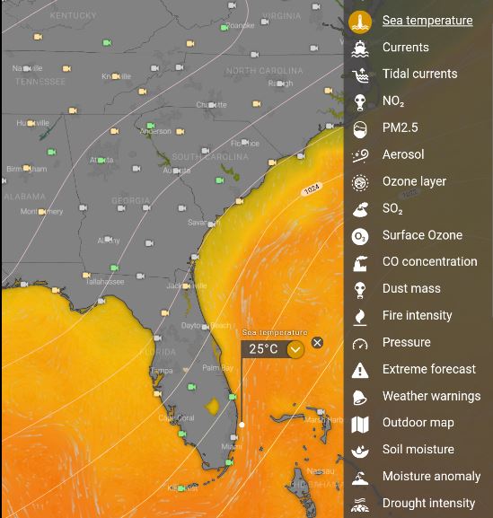
Check seawater temperature
Estimated sea surface temperature at the actual time. For locations close to the coastline, the actual values are affected by the coastline, seabed shape, wind and waves.
As the depth increases, the water temperature usually decreases.
However, near the surface of the sea, there is a layer with little change in water temperature in the depth direction, a surface mixed layer.
In the case of Japan, the seawater near the sea surface is warmed by solar radiation in the summer, and the temperature difference between the sea surface and the lower layer becomes large, so the surface mixed layer becomes thinner.
In winter, seawater is cooled on the surface of the sea, and wind blowing over the sea actively stirs the water in the upper and lower layers, forming a thick surface mixed layer.
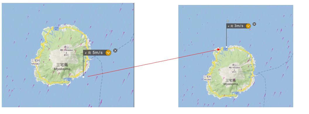
Fishing-Find back wind!
A big problem in fishing is the headwind.
No matter how much you swing the rod, the lure will not fly. Therefore, when looking for a place where the wind is weak even a little, use Windy to search for the back of the wind.
For example, the point in the left image below has a wind speed of 5 m/s, but if you click the white point ○ on the opposite side of the island and move it, you can find a weak wind point with a wind speed of 3 m/s.
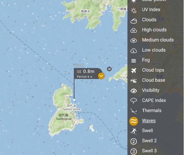
Fishing Search for waves and swells!
In order to enjoy fishing safely, it is essential to know information about waves and swells.
For example, the point in the image below is a wave with an interval of 1.4m (period: 7S) to the southeast, which is not suitable for fishing on the beach, and should be avoided.
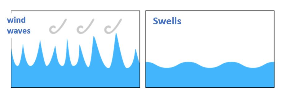
What are waves?
Waves are a combination of waves generated directly by the wind (wind waves) and gently rounded waves (swells) caused by wind waves generated in distant places.
There are two types of waves: wind waves and swells. Waves are affected by topography.
①wind waves: Waves caused by the wind
②Swells:Waves propagated by wind-generated waves in other sea areas are called swells.
Typical examples of swell include waves caused by the aftermath of storms.
Swells have a longer period and longer wavelength than wind waves.
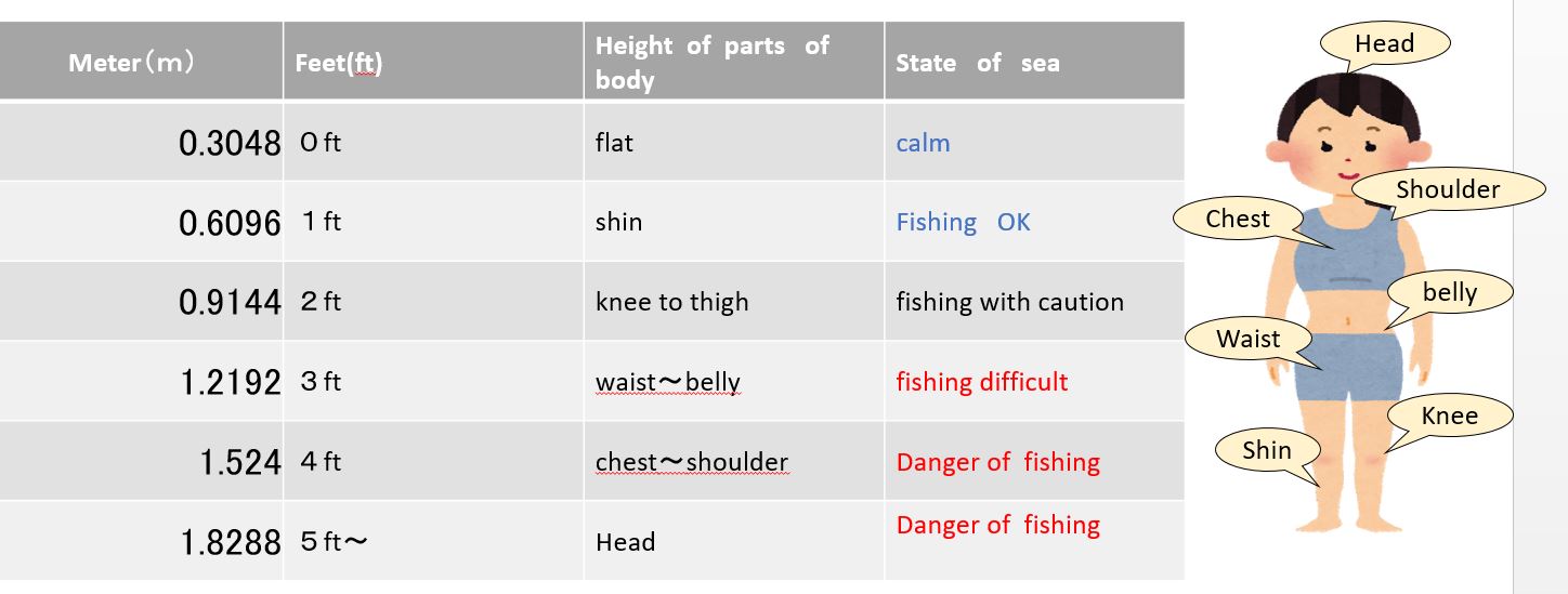
Fishing and wave height guideline
Wave heights up to 1m are safe for fishing.
Most parts of the shore may be covered with waves when it exceeds 1m.
Guide to fishing and wave cycles
The interval between normal sea swells is about 3 seconds .A wave with a period of 6 seconds or less is a wind wave. For longer periods, the speed of the waves increases, the amount of moving water increases, and the power increases.
8 seconds or more is a dangerous level, move to a safe place. If the interval between swells (wave period) is long, the beach will be rough and it will be difficult to get out of the kayak. Also, even if you fish from the shore, the bottom will be rough and you will not be able to catch it.
| swell cycle | Note |
| 3 seconds or less choppy waves | clam |
| 4〜5 seconds wind wave |
There is a little swell. Fishing from tetras is dangerous |
| 6〜7 seconds | It is quite undulating. It’s okay if it’s a high scaffolding embankment. |
| 8 seconds less | It’s pretty rough. Move to a place in the bay where the waves are calm |
For example, if the wave height is 0.7m and the swell interval (wave period) is 8 seconds, a wave of about 0.7m will come every 8 seconds.8 seconds between swells (wave cycle) is a dangerous number.
Due to the amplification of the power of the swell that entered the shallow waters of the coast, there is a possibility that the waves will sometimes reach twice the average value.
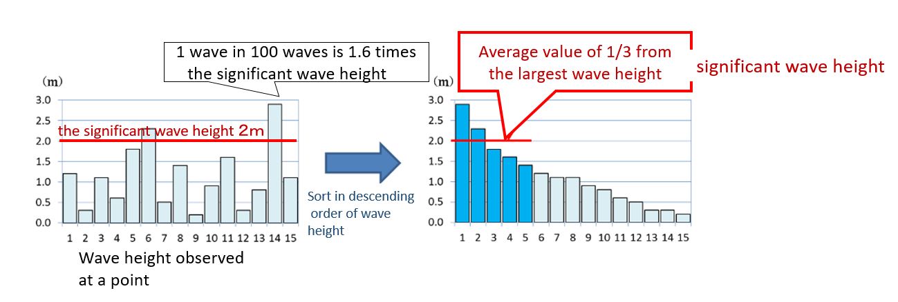
Fishing and Significant Wave Height
Wave heights used in weather forecasts are usually expressed as significant wave heights. Significant wave height is the average value of the top 1/3 of all wave heights arranged in descending order, which is close to the wave height that people intuitively perceive.
However, even with this convenient “significant wave height”, larger and smaller waves are generated.For example, 1 wave in 10 waves is 1.3 times the significant wave height, 1 wave in 100 waves is 1.6 times the significant wave height, and 1 wave in 1000 waves is twice the significant wave height.
In addition, one wave in thousands or tens of thousands of waves may be several times the significant wave height, and this is called a big wave. In this way, waves with high heights that occur stochastically, even though they are small in proportion to the whole, are called big waves.When fishing at sea, you have to be careful of big waves that come once in tens of thousands of times.
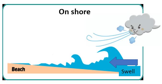
Fishing – Onshore, Offshore
If you plan to go beach fishing, check the wind direction on Windy.com to make sure the wind direction is offshore and suitable for fishing.
You can cast a lure offshore, but you can’t cast a lure onshore because of the headwind.
Offshore (wind that blows from the shore toward the sea)
conditions are good and the waves are good.
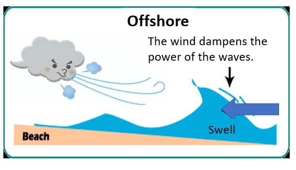
Onshore (wind that blows from the sea toward the shore) conditions It becomes a turbulent, jumbled wave.
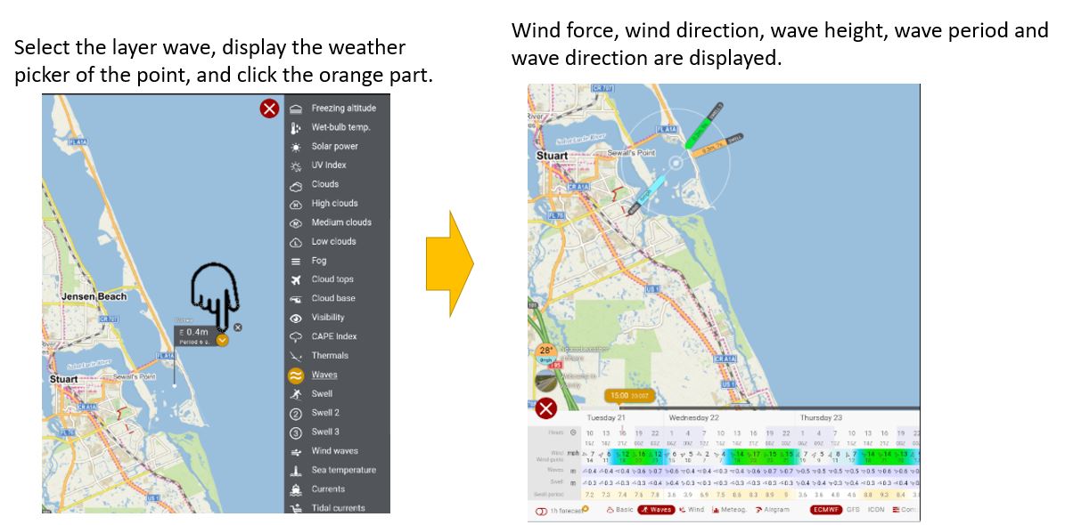
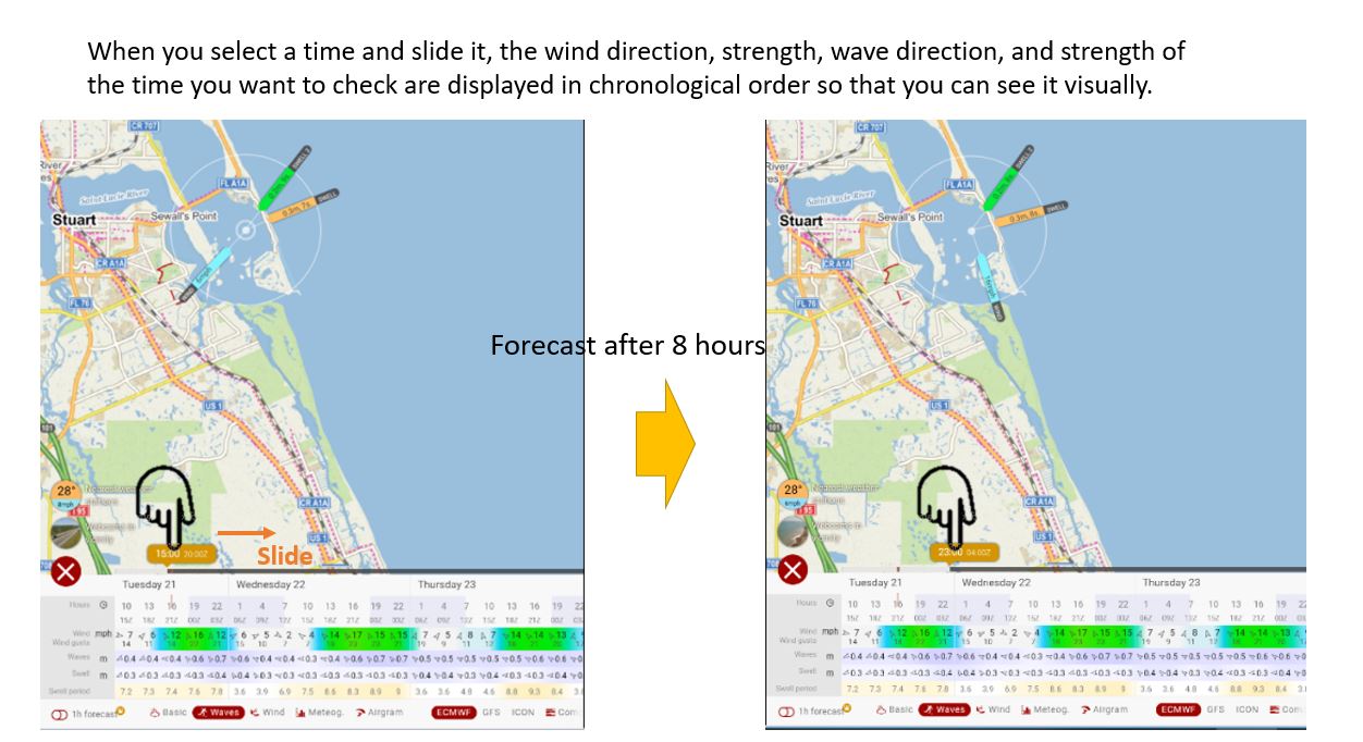
Check wind force, wind direction, wave height, wave period, wave direction
If you want to check the wind force, wind direction, wave height, wave period, and wave direction with Windy, follow the steps below.
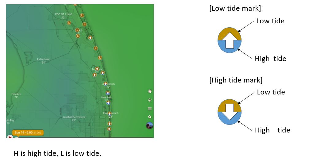
Tide forecast tide graph
The tide at each point is brown for low tide and light blue for high tide, so you can see the tide status with the high and low tide mark.
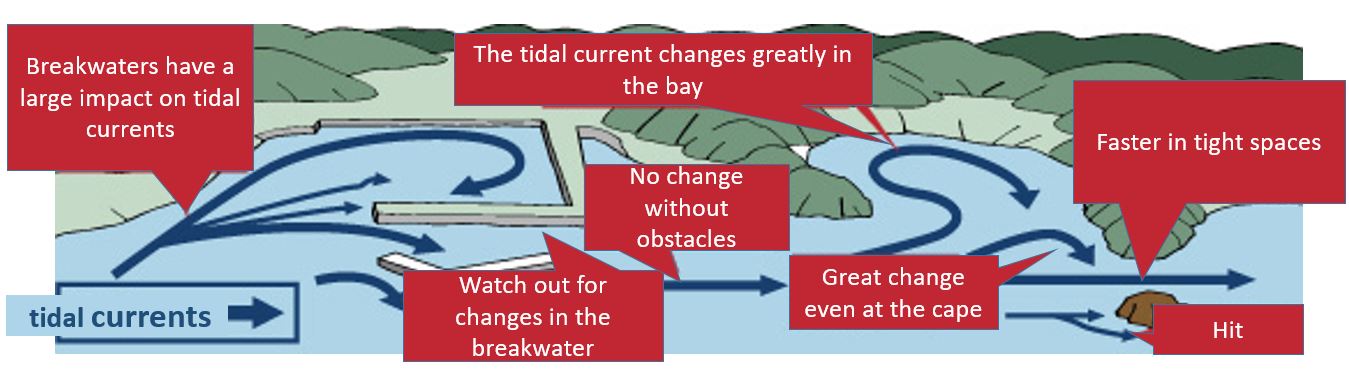
Fishing – tidal currents, ocean currents
There are tidal currents and ocean currents as major currents in the sea.
Currents that flow in a certain direction are called ocean currents. A tidal current is the flow of seawater created by the ebb and flow of the tide, and refers to the flow of seawater that changes about 180 degrees between high tide and low tide.
The most relevant data for land fishing and breakwater fishing is the tidal current data.
The notation of Windy.com makes it much easier to understand the “flow direction” when viewed on a computer, and it is difficult to understand on a tablet or smartphone.
ocean currents
tidal currents
Fishing Movement of the tide
If you go fishing on the breakwater, the current will change due to the influence of the topography.
When casting floats, baits, and lures, consider the movement of the tide when casting.
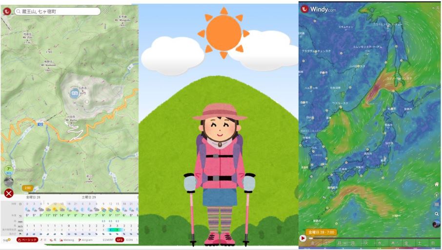
Fishing Rain forecast and measures
Fishing on rainy days has the potential to lead to accidents and serious injuries.
Hypothermia can occur, for example, when the skin and clothes get wet with rainwater.
When Fishing , be sure to pack your rainwear in your backpack.
Also, swamps and rivers are swollen, visibility is bad, and it is dangerous.
The mountain trail is dimly lit with the sunlight blocked, and sometimes you may get lost because you don’t know where you are walking.
Before fihing , check weather information such as Windy to see if there is an approaching cyclone, tropical cyclone, typhoon, or cold front.
It is also possible to check the occurrence of clouds in the mountains using the “Meteogram” function of Windy, which is helpful.
Fishing Windy Meteogram
You can see the clouds at different altitudes.
When “Meteogram” is selected, temperature, dew point temperature, wind, and cloud cover/rainfall/convective rainfall by altitude (9km, 5km, 3km, 2km, 900m) are displayed in chronological list.
Therefore, you can see “weather” and “degree of cloudiness” at a glance.
*At ground level it is 1013hPa (1 atmosphere), and as the altitude increases by 1000m, the atmospheric pressure decreases by about 100hPa.At the summit of Mt. McKinley (6190m), the atmospheric pressure is about 394hPa.
*Flight Level (FL) is one of the flight altitudes used in aviation.”FL” followed by a number in units of 100 feet.
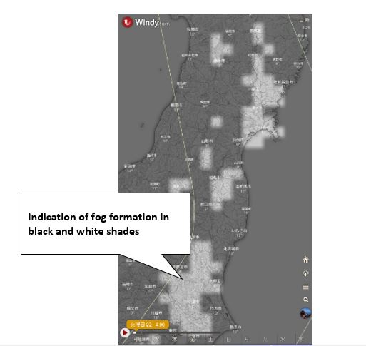
Fishing Fog, gas forecast and measures
There are places where fog is likely to occur due to topographical surfaces and natural conditions.
As the temperature rises, the air near the ground cools and the morning fog disappears.
Fog is a state in which water droplets and moist particles that are smaller than raindrops are floating, so when you are in the fog for a long time, wear rain gear to keep your clothes dry.
Also, be careful as the stones and rocks on the mountain trail are wet and slippery.
“When you are covered in fog, it is necessary to remember how to use the GPS and compass and how to read topographical maps in order to avoid getting lost.”
In Windy, there is a fog item in the layer, and you can see the occurrence of fog with black and white densities,
but please note that the weather conditions at the top of the mountain are different because it is information on the ground surface (altitude zero).
Fishing Thunder forecast and measures
If you get hit by lightning, you die.
Especially in the case of fishing, lightning strikes easily because you have a fishing rod.
If a thunder warning is issued, stop fishing immediately even if there is no thunder yet.

Before Fishing, check weather information such as Windy to see if low pressure, tropical cyclones, typhoons and cold fronts are approaching.
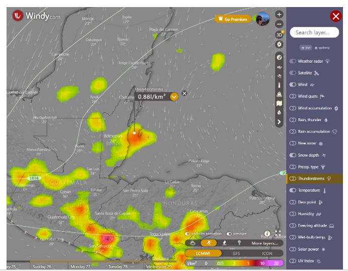
In Windy, you can check the forecast in the layer “Thunderstorm”.
Defined as the number of flashes of light in an area of 1 square kilometer in a day, the unit used to express the intensity of a “thunderstorm‘’ is “l/km2‘’.
l is the average total lightning density. The name of ECMWF is Averaged total lightning flash density in the last 3 hours
Abbreviation is litota3
The ECMWF description shows the total lightning flash rate averaged over the last 3 hours.Having units of flashes per square kilometer per day, it is easier to understand by converting to units of flashes per 100 km2 per hour.
引用先:ECMWF
The higher the number, the higher the probability of lightning occurrence.
(the more the color becomes red or purple)
Please also check the lightning radar of other weather apps before fishing.
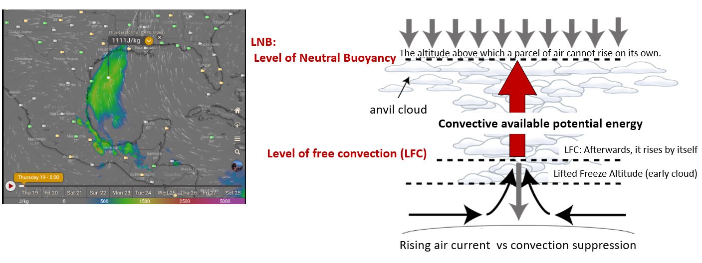
The layer CAPE index (convective effective potential energy)
The layer CAPE index (convective effective potential energy) is also useful for lightning forecasts. Stable up to 1000.
Values from 1000 to 2000 can indicate forming of moderate thunderstorms, and over 2000 severe ones.
summary:
The weather forecast app Windy.com is a free app that tells you the weather conditions at a glance on a screen that visualizes weather information around the world.
However, it is prohibited to be overconfident with Windy.com alone.
Please also check the weather forecast of others App.
Windy Related article
Windy’s related article is below, please refer to it.
How to use Windy.com for sea, river, mountain weather forecast
windy.com Types and descriptions of the display on the map
Windy.com Mountain Climbing Utilization Editionきうん)Windy.com What kind of layer?
Windy.com Utilization of fishing
Windy.com Surfing Utilization Edition
コメント